Broulee Mossy Point Community Association SPOT THE DIFFERENCE Those of you who have followed this development through the “community consultation” process, which started in 2015, may be forgiven if you are confused to see the 25 blocks of Stillwater Place and Ocean Mist Place being proposed to the west of Captain Oldrey Park.
Below are some of the plans provided by Council during the consultation process.


Above: A concept map of the development produced by Council Planning Department as part of Community Consultation. The area to the west of Captain Oldrey is clearly labelled as "Expansion of Captain Oldrey Park / Stormwater Detention". A 400m radius shows the vicinity to this Green Space for residents of the Development.

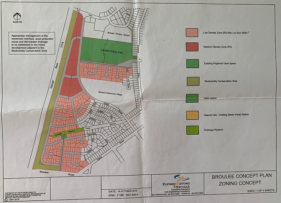
Above: Zoning Concept Plan - produced by the developer and provided by the Council Planning Team as part of the Community Consultation. The area to the west of Captain Oldrey is clearly labelled as "Open Space"
In ALL plans presented to the community during the consultation process, this land has always been shown in GREEN and labelled as “Open Space” or “Stormwater Detention”, one plan provided by Council and the Developer even labelled this land as “Expansion of Captain Oldrey Park”. One plan shows a radius of 400m emanating from this area to highlight how close this green space was to the rest of the development.
In addition to the multiple versions of the plans provided during consultation unambiguously showing this land as Green space, members of the Council Planning Department at numerous public and private meetings with the Community stated that this land would be zoned as Private Recreational (RE2) and NOT Residential (R2). This section of land was used as the key example (both written, in maps and verbally) of how the developer was incorporating green space into the development.
Fast forward to this week's DA submission and see if you can spot the difference (in the attached image) to the plan presented during Community Consultation on the LEFT and the same area submitted as part of the DA on the RIGHT. The Green Space has been replaced by 2 new roads and 25 blocks.
It makes us curious (and furious):
*. What caused the change to remove Green Space and convert it to residential?
*. Were these additional blocks (and associated population) included in all the planning figures required as part of the development process?
*. Was this change to zoning (of Stillwater Place and OceanMist Place) included in the plans that were submitted to the planning Minister Rob Stokes for Gateway Determination?
*. What is the expected value of those 25 blocks as a result of this change?
*. Is it legal and ethical to conduct a community consultation where a huge area in the development is shown as green space, then have it developed as residential housing?
*. Do the Council Planning Department think it is best practice in community consultation to placate residents with what you think they want to hear, only to do the opposite?
*. Do Council acknowledge that there was any deficiency in the community consultation process. Is there any accountability for the Council Staff for poor performance?
We will be demanding that this area is retained as Green Space as was promised during community consultation.
----
We also noticed that the other “Green Space”, that was highlighted in Community Consultation, at the end of May Place has shrunk from a block-sized green area to a concrete path (see below) - maybe the Council Planning team were intending the concrete to be painted green when they selected Green to represent this area on the map?

Above: A comparison of the "Green Space" highlighted in the concept plan and the reality of the DA.


